Post ID: 64
| Reign: |
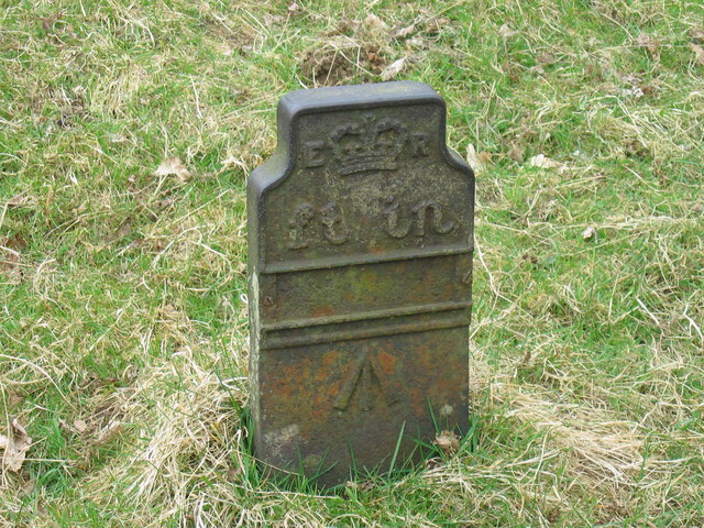
ER (Edward VII: 1901 - 1910) Later style |
| Numerals: |
None remaining
|
| Last confirmed: |
26 April 2006 |
| Location: |
Geltsdale, nr. Castle Carrock, Cumbria
|
| Depth: |
Buried to just below broad arrow. |
| Condition: |
Intact |
| Adjacent cover: |
No adjacent box cover. |
| Lat / Lng: |
 54.88707900,-2.67043700
Grid Ref:
NY 5708 5490
54.88707900,-2.67043700
Grid Ref:
NY 5708 5490
|
| Notes: |
Could this be in the middle of woods? Location is unclear but description suggests it may be... We think this was a "local" telegraph route from Carlisle, used during the building of the Castle Carrock reservoir and associated works in the Gelt valley. See www.northpennines.org.uk/castlecarrockreservoir/ for more information. |
| Web Reference: |
www.geograph.org.uk/photo/159110
|
| Identified by: |
Les Hull |
| tilt=0.00000000000000000
direction=0.00000000000000000
zoom=0.00000000000000000
|
| Featured as Post of the Month for April 2022 |
| Added to database: |
17/08/2020 23:15 |
| Last updated: |
27/04/2026 23:17 |
© Les Hull License
Photo taken Apr 2006
If you wish to contact me with feedback and suggestions for the GPO Markers website, please use the form
here.
If you have additional information or images of this marker, please
click here and complete the form.